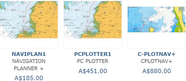
Navionics Trip Planning Software NaviPlan, PCPlan & C-PilotNav
Plan Your Trips with Ease
Save Navionics TM nautical and SonarChartTM to your PC and plan a trip.
Plan with your PC at home, on board or in the office and transfer routes and waypoints to your chart plotter. NavigationPlanner allows you to backup all your waypoints and routes on your PC, import data from other sources and transfer them to your plotter.
Owners of chart plotters (using Navionics charts) can transfer routes and waypoints between PC and chart plotter.
- View and save NavionicsTM nautical charts on your PC and plan a trip
- View and save SonarChartTM on your PC and find and mark your favourite fishing and diving spots
- Transfer routes and waypoints from any NavionicsTM based chart plotter to and from your PC
- Load, create and save waypoints and routes
- Keep your own waypoint library, import waypoints from CSV files and other sources
- Use the same chart symbols on your plotter and PC
- Create a route with a few mouse clicks
- Show charts in International or US colours and symbols
- Set a safety contour with a few clicks of the mouse
- View and print full details of your routes and waypoints
- Locate ports with the Go-to-port function
- Measure distances, bearing, fuel use and much more
- Access tide & current, sun & moonrise data - show tidal flow direction and velocity on chart (subject to chart data availability)
- Compatible with Windows XP to Windows 10
- Multilingual
- Can be activated on up to three PCs
- Try a free two week trial of Theyr weather
- Download weather information including wind, wave, rain etc. Set maximum wind speed and wave heights and see those and higher values displayed in red as you step through the forecast.
- The following manufacturer's plotters* are compatible with PCPlotter...
![]()
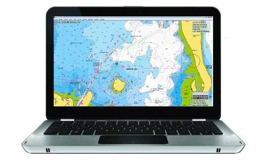
Your onboard navigator
Install PC PLOTTER on your laptop or Windows tablet, save your NavionicsTM chart to the hard drive and you have an onboard chart plotter.
- View and save NavionicsTM nautical charts on your PC and plan a trip
- View and save SonarChartTM on your PC and find and mark your favourite fishing and diving spots
- Transfer routes and waypoints from any NavionicsTM based chart plotter to and from your PC
- Load, create and save waypoints and routes
- Keep your own waypoint library, import waypoints from CSV files and other sources
- Use the same chart symbols on your plotter and PC
- Show charts in International or US colours and symbols
- Set a safety contour with a few clicks of the mouse
- View and print full details of your routes and waypoints
- Locate ports with the Go-to-port function
- Measure distances, bearing, fuel use and much more
- Access tide & current, sun & moonrise data - show tidal flow direction and velocity on chart (subject to chart data availability)
- Display vessel position when linked to a position fixer via an NMEA source (both NMEA 0183 and NMEA 2000)
- Calculate the optimum route using tidal information
- Calculate and display active route information
- Recalculate route and time to go taking into account tides and boat speed at any time during passage
- Overlay AIS information when connected to an AIS receiver/transceiver
- Overlay radar targets when connected to a RADAR output
- Calculate time and distance of Closest Point of Approach (CPA) to AIS/RADAR targets and sounds alarms
- Overlay weather data from downloaded GRIB or Theyr weather files (for Theyr set maximum wind speed and wave height and see these and higher values in red as you step through the forecast) - free two week Theyr trial available
- Display any instrument information that is available through NMEA
- Compatible with Windows XP to Windows 10
- Can be activated on up to three PCs
- Multilingual
The following manufacturer's plotters* are compatible with PCPlotter...
![]()
TMQ'S INTUITIVE, COMPREHENSIVE CHART PLOTTING SYSTEM
Available in multiple versions, CPLOT is a reliable and easy to use computer-based chart plotting system designed for both recreational and professional applications.
Navionics Cartography:
Incorporating Navionics charting capabilities, the system links with new cartography for ease of management and navigation. C-PLOT can be integrated via standard NMEA 0183 to provide extra user information via AIS.
Specifications:
User Requirements:
- Intel Powered® Microsoft Windows Operating System.
- Windows 7, 8 & 10 compatible Windows Vista
- 2 USB Serial Ports (recommended)
- 1 Serial Port (recommended)
- Mouse or other pointing device
- Input Data NMEA 0183
- Output Data NMEA 0183
- Ethernet UDP (hardware required) Internet access (installation and updates)
Connectivity:
C-Plot Nav+ can be integrated via standard NMEA 0183 to radar for ARPA target, sounder for temperature and depth, autopilot for route steering and AIS target information including other vessel name and MMSI number.
Charts:
C-Plot Nav+ supports Navionics+ cartography, providing flexible charting with constant updates.
Just select an area of coverage within your region and download the required chart data to your card. You can download updates or new areas at any time during the following 365 days.
Main Features:
Display:
The screen displays all navigational data overlaid on a user-selected chart with a GPS input, the vessel’s position, speed and heading are displayed. Using NMEA 0183 compatible equipment, depth, temperature, heading and AIS targets can be displayed and stored to enhance navigation data.
Track:
Indicates historical information on vessels’ past movement. Track points can be recorded by user-defined distance or time intervals. C-Plot Nav+ offer 16 user-defined colours for vessel track, depth and temperature.
Assisted Routing:
By simply selecting two points, C-Plot Nav+ will calculate a safe and navigable route for you to follow. (Only available outside the USA)
User Data:
Routes, marks and events can be added easily by either point and click or menu function. Since C-Plot Nav+ is a computerbased system, the amount of user and navigation system stored is only limited by the computer hard drive capacity.
Range and Bearing:
Controlled by the cursor, C-Plot Nav+ provides navigational information such as the bearing and distance between two points or between your vessel and a fixed point.
Closures:
C-Plot Nav+ allows the user to load and display files from other mapping systems. These files can be closures or restricted areas or SAR patterns.
3D Seabed Mapping:
C-PLOT 3D (optional extra) is a comprehensive three-dimensional mapping tool that shows you exactly what is happening beneath your vessel. View the seabed, fishing hot spots and underwater conditions all in an animated 3D landscape.
Compatibility Guides
Check our Compatibility Guides for:
- Plotter – Europe, Middle East, Asia, Africa, Pacific
- Plotter – Americas
- Plotter – Navionics Updates
- Plotter – Lowrance, Simrad and B&G - Depth Data Export in GPX format
- Chart Installer - Operating Systems
- Plotter/Mobile – SonarChart™ Live
- Mobile – check on the Navionics Boating page
- Mobile – Other apps with specialized features that support Navionics charts
(615637)
| SKU | 615637 |